|
Welcome to Drone
Aerial Panoramic Photography in full
360 degrees! This is a unique service
that can demonstrate an amazing a panoramic view from any altitude. This service is
great for developers who are building high rises condos or office
buildings that are still under construction and want to sell "The View"
condos or apartments not yet
complete. Many developers call these Aerials
View Photography.
Creating a 360 Panoramic from the equivalent altitude of lets say every
5-10 floors can help buyers decide what floor they want to purchase and
help sellers decided how much to charge. Altitude is measured by the
drone by onboard GPS in meters and is accurate to within 6 feet.
Ask us about
spherical aerial photography where you
can look up and down if needed.
Example. Client in Manhattan wanted to show future views from various future floors
of a building to be constructed to sell apartments or condominium at
according to their view. There are several floors you can click on and
you can scroll left and right in this interactive 360 tour.
Click each image to enlarge in a new window.
Latest Style
Virtual Tours!
Interactive Flash 360 Panoramic Elevation
Future Views:
West side New York at Sunset on the Hudson
River
Use thumbnails to explore other altitudes!

Uptown Manhattan low level 360 aerial with
map
Use thumbnails to explore other altitudes!

Panoramic aerial photography Lexington Ave
Midtown Manhattan

2nd Avenue 360 degree panorama aerial
photography New York

Los Angeles California - Ocean Ave at
Santa Monica Blvd Condo Future View Floor 15
Previous Style of Standard Image 360
Future Elevation Future Views:
(contains one image at one altitude use mouse to scroll
left and right)

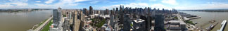
New York City Harbor Aerial 360 Degree Panorama

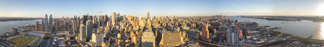
Midtown Manhattan 360 Degree Panoramic
Aerial Photography

New York City Midtown, Just Over Times Square
- 360 Degree Aerial Photography from the top floor of a proposed building
yet to be built.
New York City West Side 59 Street at the
Hudson River
- 360 Future View from the top floor of a proposed building
yet to be built. Use this for your proposal!
|